
By José Jesus Delgado Peña, Professor at Universidad de Málaga, Spain
The mountains of Spain are far more than a scenic backdrop, but rather a structurally defining part of the country. From the Pyrenees to Sierra Nevada, Spain’s mountains shape the country’s climate, water systems, ecosystems, and settlement patterns. Their complex geology creates contrasts between humid Atlantic regions, dry interiors, and cold high-altitude zones. Vegetation patterns reveal strong human influence, as native forests have often been replaced by plantations, shrubland, and agricultural land. In the volcanic landscapes of the Canary Islands, subtropical conditions add yet another layer of diversity. Read on to understand how together, these mountain regions form environmentally rich but structurally vulnerable territories that remain central to Spain’s ecological and socio-economic landscape.
The Distribution & Geomorphological Characteristics of the Mountains of Spain
Spain displays a remarkable mountain diversity that decisively shapes its relief, climate, hydrography, and human settlement. This complexity is explained by the interaction between ancient Hercynian massifs, rejuvenated or fragmented, and younger mountain ranges formed during the Alpine orogeny. The arrangement of Spain’s mountains largely reflects the structure of the Central Plateau (Meseta) and the presence of peripheral and external systems, as follows:
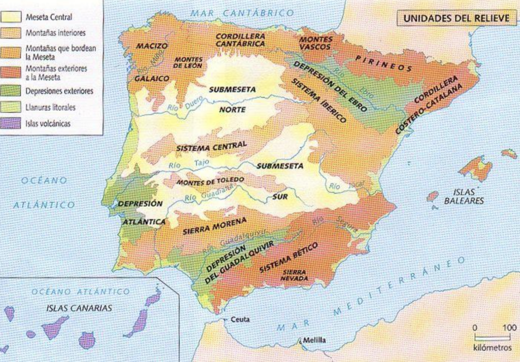
In the northern part of the peninsula, the Pyrenees stand out as a compact mountain barrier between Spain and France. They are characterised by high altitudes and steep profiles, with a predominance of folded materials formed during the Alpine orogeny. In the highest areas, they display typical glacial landforms such as U-shaped valleys, cirques, and lakes. To the west of the Pyrenees lies the Cantabrian Range, which runs parallel to the Cantabrian coast, with steep slopes toward the sea and a highly eroded relief dominated by limestone materials that give rise to karst landscapes.
In the interior of the peninsula, the Meseta is structured by mountain systems of ancient origin. The Central System divides the Meseta into two sub-plateaus and features a relief of uplifted and subsided blocks (horsts and grabens), with rounded summits and medium elevations. Complementarily, the Montes de Toledo present a lower, gently undulating relief, the result of intense erosion.
Surrounding the Meseta are peripheral mountain ranges such as the Iberian System, which has a complex structure of aligned ranges and an alternation of limestone and siliceous materials, producing a highly contrasted relief. To the south, Sierra Morena acts as an elevated step separating the Meseta from the Guadalquivir Depression, with smooth landforms and relatively modest summits.
Finally, in the southern and southeastern parts of the peninsula lie the Baetic Ranges, one of the most complex mountain groups from a geomorphological perspective. They include young, rugged ranges with great lithological diversity. Within them is Sierra Nevada, which contains the highest elevations in peninsular Spain and shows clear evidence of glacial modelling.
Overall, Spain’s mountains are distributed both peripherally and within the interior, combining ancient and rejuvenated reliefs with young Alpine ranges. This geomorphological diversity accounts for the rich landscapes of Spanish territory and its marked regional differentiation.
Resource: Atlas Nacional de España, IGN.
The Köppen Climate Classification in Spain
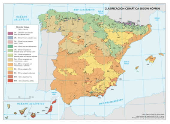
The Köppen climate classification is one of the most widely used systems worldwide for identifying and distinguishing climates based on average temperatures, precipitation, and their seasonal distribution, as well as the relationship between climate and vegetation. Spain, due to its geographical position, complex relief, and the influence of both the Atlantic Ocean and the Mediterranean Sea, shows a great climatic diversity, clearly reflected in this classification. The main different areas are:
- The Mediterranean climate (Group C) is predominant across most of Spain. It is characterised by dry, hot summers and mild winters, with irregular precipitation concentrated mainly in autumn and spring. Within this group, several variants can be identified. The typical Mediterranean climate (Csa) extends over most of the Iberian Peninsula and the Balearic Islands, with very hot summers and a marked summer drought. The warm-summer Mediterranean climate (Csb) appears in parts of the northwestern peninsula and in higher-altitude areas, where summers are milder. Meanwhile, the continentalised Mediterranean climate of the interior of the peninsula has colder winters due to altitude and distance from the sea, although it maintains the characteristic summer drought.
- In the northern part of the peninsula, especially along the Cantabrian coast, the oceanic climate (Cfb) predominates. This climate is characterized by abundant and evenly distributed rainfall throughout the year, mild temperatures, and a low annual thermal amplitude. The influence of the Atlantic Ocean and the presence of the Cantabrian Mountains enhance humidity and explain the development of green landscapes and deciduous forests.
- In the southeastern peninsula and in specific areas of the Mediterranean coast, the semi-arid or steppe climate (BSh and BSk) appears, characterised by very low precipitation, high levels of sunshine, and frequent droughts. This climate is shaped by the rain shadow effect of the Baetic Ranges and the influence of dry air masses, resulting in arid landscapes and vegetation highly adapted to water scarcity.
- In high mountain areas, such as the Pyrenees (Dfb, Dfc), the Central System (Dsb), or Sierra Nevada (Dsb, Dsc), the mountain climate can be identified. It is recognized by its specific features: low temperatures, abundant precipitation, much of it in the form of snow, and a clear altitudinal climatic zonation.
- Finally, in the Canary Islands, a subtropical climate predominates (BWh and Csb, depending on the area), strongly influenced by latitude, the trade winds, and volcanic relief. This climate features mild temperatures throughout the year and a wide variety of microclimates, ranging from very dry areas to humid zones on windward slopes.
Applying the Köppen classification to Spain highlights an extraordinary climatic diversity, resulting from the interaction between latitude, relief, and air masses. This diversity explains the richness of Spain’s landscapes, ecosystems, and human environments, as well as the marked regional differences in lifestyles and economic activities.
Resource: Atlas Nacional de España, IGN.
Forest Types in the Iberian Peninsula, the Balearic Islands, and the Canary Islands
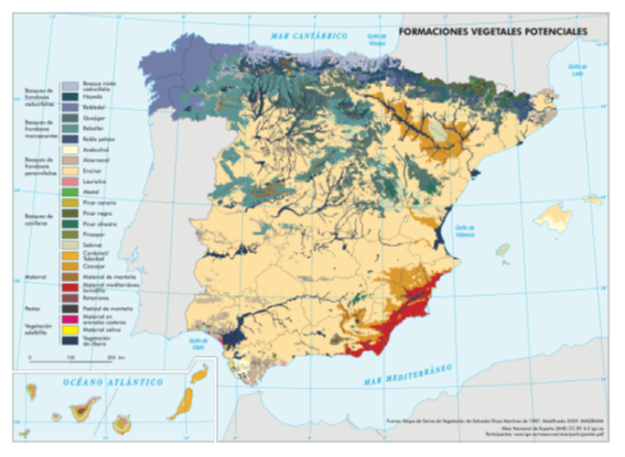
Following the data from the Atlas Nacional de España (Instituto Geográfico Nacional), the analysis of potential and current vegetation makes it easier to understand the extent to which human activity has transformed forest landscapes in Spain. Based on the data provided, significant differences can be observed both between territories (the Iberian Peninsula and the Balearic Islands versus the Canary Islands) and between what could naturally exist and today’s reality.
The Forests of the Iberian Peninsula and Balearic Islands
In terms of potential vegetation, the forest landscape of the Iberian Peninsula and the Balearic Islands would be clearly dominated by evergreen broadleaf forests (58.6%), mainly holm oak and cork oak woodlands typical of the Mediterranean climate. These would be followed by marcescent broadleaf forests (15.6%), characteristic of transitional climatic zones, and deciduous forests (10.3%), associated with wetter areas in the north and mountainous regions. Coniferous forests would have a very limited presence in the potential landscape (3.6%), indicating that their current widespread distribution does not respond to natural conditions but rather to human intervention.
However, current vegetation reveals a very different reality. Evergreen broadleaf forests are drastically reduced to 14.5%, while deciduous and marcescent forests are limited to very low percentages (2.8% and 3.6%, respectively). In contrast, coniferous forests increase significantly to 15.7%, reflecting the impact of forest plantations carried out for productive purposes and soil protection. In addition, shrubland (13.2%) and non-forest surfaces (45.9%) occupy a very large part of the territory, evidencing processes of deforestation, forest degradation, and the expansion of agricultural, urban, and infrastructural land uses.
Forests of the Canary Islands
In the case of the Canary Islands, potential vegetation shows a different balance, strongly conditioned by volcanic relief and the subtropical climate. Shrubland stands out as the dominant formation (47.0%), followed by coniferous forests (40.3%), mainly Canary Island pine forests adapted to fire and aridity. Evergreen broadleaf forests would play a secondary role (11.4%), while grasslands would be practically absent.
Current vegetation largely maintains this structure, although with clear transformations. Shrubland increases to 54.1%, becoming the most extensive formation, which indicates processes of forest degradation and replacement. Coniferous forests decrease markedly to 13.0%, and evergreen broadleaf forests are reduced to 2.8%. There is also a significant proportion of non-forest surface (26.9%), linked to human settlement, infrastructure, and agricultural and tourist areas.
Overall, the data reveal a strong contrast between potential and current vegetation, especially in the Iberian Peninsula and the Balearic Islands, where natural broadleaf forests have been largely replaced by coniferous forests, shrublands, and non-forest surfaces. In the Canary Islands, although shrubland was already naturally dominant, the reduction of potential forests and the increase in altered surfaces also show a significant human footprint. Overall, issues surrounding deforestation and the spread of human living space has negatively impacted the forest diversity in these areas. This analysis highlights the need for forest conservation and restoration policies aimed at recovering, as far as possible, plant formations that are more consistent with the original ecological conditions of each territory.
Resource: Atlas Nacional de España, IGN.
Challenges in the Marginalised Mountainous Areas of Spain
This first overview of the specific challenges faced by different marginalised mountain communities in Spain shows how problems vary by territory rather than being uniform across all mountain areas.
1. Spain’s Northern Mountain Areas: The Pyrenees & Cantabrian Mountains
Communities in the Pyrenees and the Cantabrian Mountains face long-standing demographic and economic pressures. Key challenges include:
- Depopulation and ageing due to the out-migration of young people.
- Limited economic diversification, with declining traditional livestock farming and forestry.
- Restricted access to services (healthcare, secondary education, public transport).
- Climate change impacts, including reduced snow reliability, threatening winter tourism.
- Land abandonment, increasing wildfire risk and landscape degradation.
Resource: actualidadviajes.com
2. Central Mountain Systems: Sistema Central & the Iberian System
In interior ranges such as the Sistema Central and the Iberian System, marginalisation is closely linked to Spain’s so-called “empty interior”. Key challenges comprise:
- Very low population density and loss of basic services.
- Economic fragility, with limited employment beyond extensive agriculture.
- Digital divide, affecting access to online education, administration, and markets.
- Weak transport connectivity to urban centres.
- Heritage degradation, as historic villages lack resources for conservation.
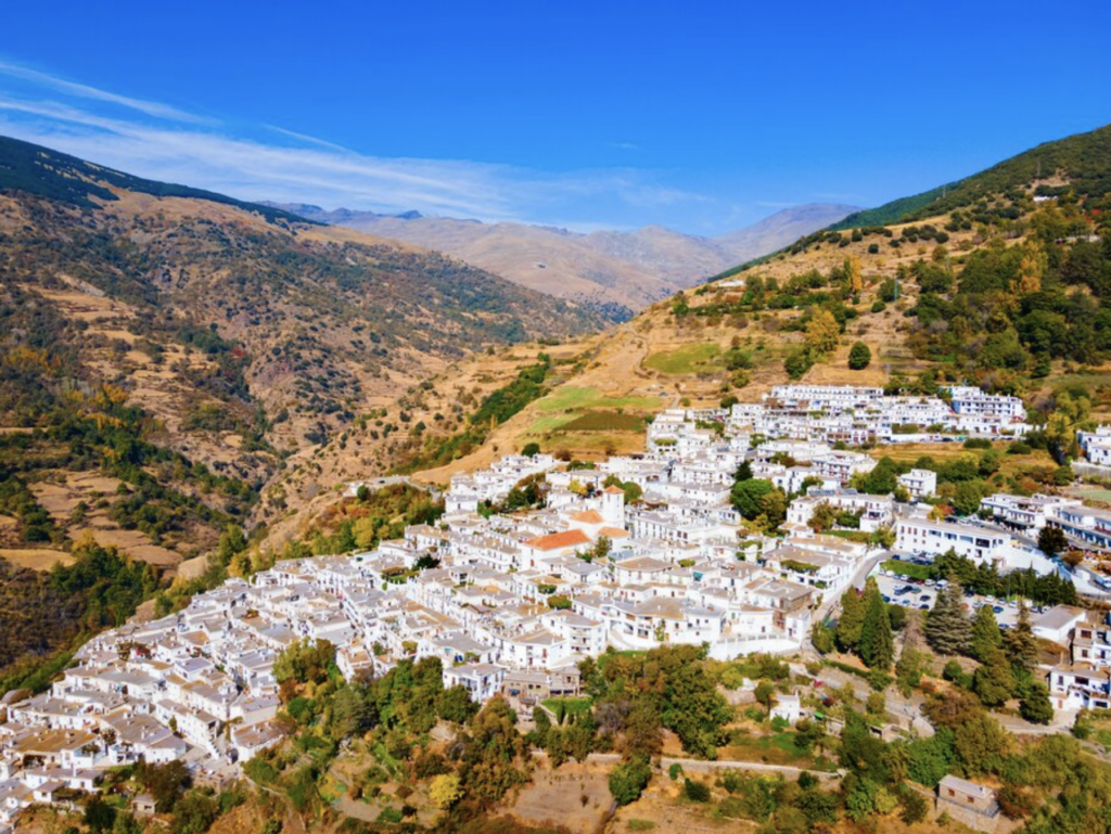
3. Spain’s Southern Mountain Areas: the Baetic Ranges & Sierra Nevada
In areas such as the Sierra Nevada and the Alpujarra, challenges are marked by a combination of environmental stress and socio-economic vulnerability, such as:
- Water scarcity and increasing drought linked to climate change.
- Agricultural decline, especially in traditional terrace farming systems.
- Seasonal and low-paid tourism, offering limited long-term stability.
- Risk of landscape abandonment, threatening cultural landscapes and biodiversity.
- Youth out-migration, despite strong local identity and heritage
Resource: kimkim.com
4. The Mountain Communities of the Canary Islands
In the mountainous interiors of islands such as Tenerife or La Palma (within the Canary Islands), marginalisation has distinct insular characteristics. These include:
- Double isolation through a mountainous terrain, combined with island geography.
- Limited land availability and soil erosion on steep volcanic slopes.
- Economic dependence on coastal tourism is marginalising interior areas.
- High vulnerability to natural hazards, including volcanic eruptions, landslides, and wildfires.
- Demographic imbalance, with population concentration on the coast.
It is important to highlight the primary cross-cutting challenges common to most mountain communities, as, despite regional differences, many problems are shared:
- Demographic decline and ageing
- Limited access to education, healthcare, and housing
- Climate change exposure (fires, water stress, extreme weather)
- Weak political visibility in national and regional decision-making
- Underuse of local knowledge and cultural heritage
In conclusion, marginalised mountain communities in Spain face territory-specific challenges shaped by geography, climate, and historical development, but all share structural disadvantages related to depopulation, service access, and economic vulnerability. Addressing these challenges requires place-based policies, combining rural development, climate adaptation, digital connectivity, and the valorisation of mountain heritage and traditional knowledge rather than one-size-fits-all solutions.
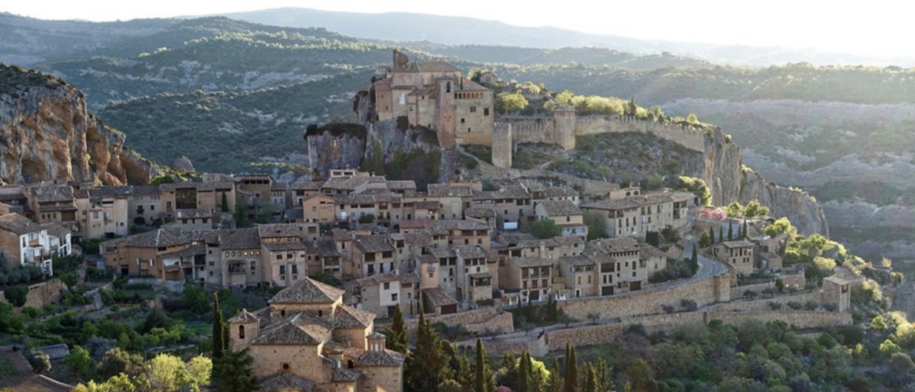
The header image was provided by Jesús Delgado.
Explore MARGISTAR’s Spain Country Focus
